When x-ray vision is a reality, not a superpower
See glaciers, dams, mountains, buildings, art, and railway stations in a fascinating new light: ETH spin-off Scanvision combines laser scanning and photogrammetry technologies to visualise large-scale landscapes and constructions in 3D documentations.
By combining many technologies and data sources, Scanvision creates entirely new visual experiences for applications ranging from visiting a hydropower plant in the mountains to exploring a museum, or travelling through Zurich’s multi-layer railway station.
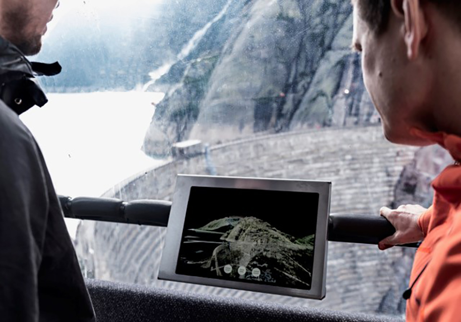
Thanks to Scanvision’s exact renderings, the deepest, darkest, and farthest recesses of constructions – e.g. hydropower plants built inside mountains – can be fully viewed and explored.


In the Grimsel external pageHospizbahn gondolas, for example, Scanvision installed an interactive augmented reality app, enabling users to see inside the hydropower system (see picture above). Standing in the gondola, users can see the various underground pipes and passages and appreciate the entire dimension of the construction behind the concrete walls.

”We combine aspects of science, art and communication in our work.” Matthias Vollmer, co-founder of Scanvision
Scanvision’s application was also used in the “Museum für Gestaltung” at the University of the Arts ZhdK. A VR application of a Japanese Garden in Kyoto enabled visitors to move freely through the garden using VR glasses and a headset.
Similarly, Scanvision’s point cloud visualisation allows you to virtually fly through the different levels of Zurich's complex main railway station, giving the viewer a clear picture of the space.. To augment the train station experience, Scanvision incorporates corresponding sounds for each area including squeaking trams overhead, track announcements on the tannoy, or the muffled chug of trains resonating through the passages.

Multiple data sources render a detailed, realistic 3D view in colour
The Scanvision team combines the key technologies laser scanning and photogrammetry to create extensive point cloud models for spectacular new pictures, apps and videos enriched with sound.
The scanning involves the recording of areas or buildings from numerous angles with a laser measuring device or a drone. Simply put, laser scanners work using a light-based measuring method in which millions of pulses are emitted at fixed angles in all directions. Depending on the reflection time of the laser beam, the exact coordinates in space are determined. The measuring points are coloured with the help of photographs.
For the corresponding sound, Scanvision works with field recording specialists. This huge cloud of data points is then interpreted three-dimensionally in colour and high resolution. For landscapes, the spatial information from the likes of external pageSwiss Topo or external pageInovitas can be merged and extended with the data collected from the laser scanner. The individually integrated sounds yield results that are even more stunning.
“The intricate details, transparency, colours, and sounds in our pictures create the magic...”Dennis Häusler, co-director Scanvision
Combining technologies and data to capture large environments and constructions
Bringing together their expertise in point clouds with strong skills in conceptual, spatial, and cinematic thinking, Scanvision pushes the boundaries of surveying and representation. The sheer scope of potential areas of use is constantly being expanded. The Scanvision team is always open for ideas of new potential partners in Switzerland and abroad.

Contact/Links:
Do you want to get more "News for Industry" stories?
external pageSubscribe to our newsletter
external pageFollow us on LinkedIn
Are you looking for research partners at ETH Zurich?
Contact ETH Industry Relations
ETH spin-offs: facts and figures
Since 1996, 471 spin-offs have been founded at ETH Zurich. ETH transfer, the technology transfer office at ETH Zurich, supports recognized ETH spin-offs in the founding process and in their first years of operation.
With the help of the Pioneer Fellowship Programme, funded by the ETH Foundation, young researchers can develop innovative products and services based on their scientific work at ETH Zurich. A Pioneer Fellowship is awarded to young ETH entrepreneurial minds intending to develop a highly innovative product or service to be exploited commercially and/or for the benefit of society.