Towards mitigating seismic hazard
A Europe-wide consortium has published the first harmonised reference model on seismic hazard in Europe and Turkey – the European Seismic Hazard Map 2013. It will be used to elaborate European and national building provisions for earthquake-proof construction. Public authorities, insurances and, last but not least, schools will likewise have the opportunity to use the map.
Italy, Iceland, Greece, Turkey: In the past these countries have suffered from catastrophic earthquakes. But even outside these high risk regions there can be strong tremors. Hence, anyone who builds, provides insurance or wishes to protect the population and critical infrastructures needs a solid understanding of the hazard situation. This foundation has now been provided by the SHARE Consortium (SHARE=Seismic Hazard Harmonisation in Europe) under the management of the Swiss Seismological Service (SED) and the Institute of Geophysics at ETH Zurich. This Consortium recently published a new seismic hazard map, the European Seismic Hazard Map 2013, for Europe as a whole and Turkey.
Seismic Hazard depicted for 120,000 sites
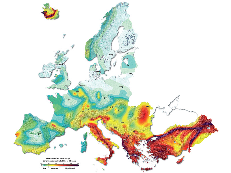
As a major result of the overall hazard model, this map presents the seismic hazard at 120,000 locations in Europe and Turkey. In various shades it indicates the long-term average ground-shaking intensity that tremors will achieve or exceed with a 10 percent probability in 50 years. The researchers chose ground acceleration that triggers horizontal movement of the subsoil in the event of an earthquake as the yardstick for intensity. The majority of Switzerland is classified as low risk – with the exception of Valais and the Basel region for which a mean risk is forecast.
The European Seismic Hazard Map 2013 is the most ostentatious result of the SHARE Consortium. “The model behind these maps is far too complex to be depicted in just one European map”, says Jochen Wössner, SED scientist and SHARE project manager. All Consortium products like maps, input data, results and documentation are, therefore, stored in a database at ETH and are freely accessible on the website of the European Facility for Earthquake Hazard and Risk (external page www.efehr.org). All further details about the projects and explanations about the maps can be found on the project page of external page SHARE.
First Europe-wide harmonised maps
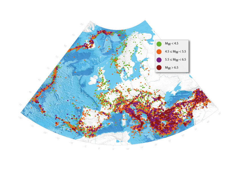
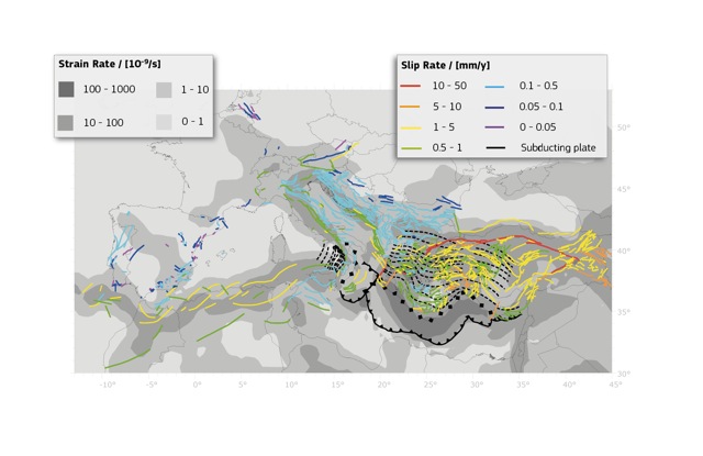
As input data the scientists analysed the 68,000 kilometres of active faults in Europe and Turkey and prepared a large scale deformation model depicting strain rates. More than 30,000 earthquakes with a magnitude of 3.5 or higher were harmonized in a catalogue. In particular the quake magnitudes were calibrated. This earthquake catalogue covers all earthquakes documented historically since the year 1000 up to quakes measured in the modern age. The researchers combined these data in a statistical process with the latest empirical ground motion models which describe the seismic wave propagation through the earths crust and their attenuation with distance. From that they calculated the hazard at each point and documented this in maps.
18 institutions from 14 countries in Europe, North Africa and Turkey were involved in SHARE. More than 300 researchers helped to elaborate the new seismic hazard model. Many of the researchers were invited to workshops and they made their expertise and data available withouth support from the European Commission – in harmony with the intention behind the project acronym SHARE.
Seismological Service paved the way
The major achievement of this seismic hazard model is that all European countries now have homogeneous reference data with which they can work on the national level. Furthermore, the hazard values can now be compared. Prior to this, they sometimes changed dramatically at national borders as a consequence of individual national projects.
The first attempts to draw up a homogeneous seismic hazard map for Europe were started by the Swiss Seismological Service in 1995. The product of that initiative – a relatively simple map compared to the current version – was published in 2000 and a revision in 2003. Ten years later new data and methods meant it was necessary to review the hazards. “We needed a new model to be able to draw conclusions about the risk, too, based on the hazard”, says Domenico Giardini, Professor of Seismology and Geodynamics and SHARE project coordinator. The risk results from the hazard and the vulnerability of buildings and their values which are present in an area.
Furthermore, in 2010 the EU introduced new building standards, the Eurocode 8. However, the foundation for this were the national seismic hazard maps which differ from country to country. “That’s why we needed a European reference map and why the EU financed the SHARE project within the framework of the 7th EU Framework Programme for Research”, explains the ETH professor. The maps are the first step towards determining the European seismic risk.
A model for engineering, insurance and mitigation purposes
The maps are particularly useful for earthquake engineers, building authorities, insurance companies or civil defence as illustrated by the access data to the project websites. The energy sector, too, is very much interested in the results as they are the basis for an EU project that is also coordinated by ETH entitled external page STREST (Harmonized approach to stress tests for critical infrastructures against natural hazards) aiming to elaborate guidelines for stress tests for critical infrastructures.
Moreover, the seismic hazard maps are to be made available to schools across Europe for their courses. The “Seismo at School” project aims to ensure that the findings of the earthquake researchers reach the attention of children and adolescents. “We want to consciously increase the culture of prevention”, says Giardini.
Above all, the building authorities and property developers must comply with the national provisions on earthquake-proof construction. The recommendation to the governments of EU Member States and Turkey is, however, that they use the new harmonised data as the basis for forthcoming reviews of national maps. The Swiss Seismological Service at ETH Zurich is currently working on a new earthquake hazard model for Switzerland and is using some parts of the SHARE model. The model is to be published at the end of 2014.
Reference
Giardini D., J. Woessner, L. Danciu, H. Crowley, F. Cotton, G. Grünthal, R. Pinho, G. Valensise, S. Akkar, R. Arvidsson, R. Basili, T. Cameelbeeck, A. Campos-Costa, J. Douglas, M. B. Demircioglu, M. Erdik, J. Fonseca, B. Glavatovic, C. Lindholm, K. Makropoulos, C. Meletti, R. Musson, K. Pitilakis, K. Sesetyan, D. Stromeyer, M. Stucchi, A. Rovida (2013), Seismic Hazard Harmonization in Europe (SHARE): Online Data Resource, doi: external page 10.12686/SED-00000001-SHARE.
Comments
No comments yet