New earthquake assessments strengthen preparedness in Europe
European scientists with the participation of the Swiss Seismological Service at ETH Zurich have published an updated earthquake hazard map and, for the first time, an earthquake risk map for Europe. Switzerland will follow suit next year with a higher resolution national risk map.

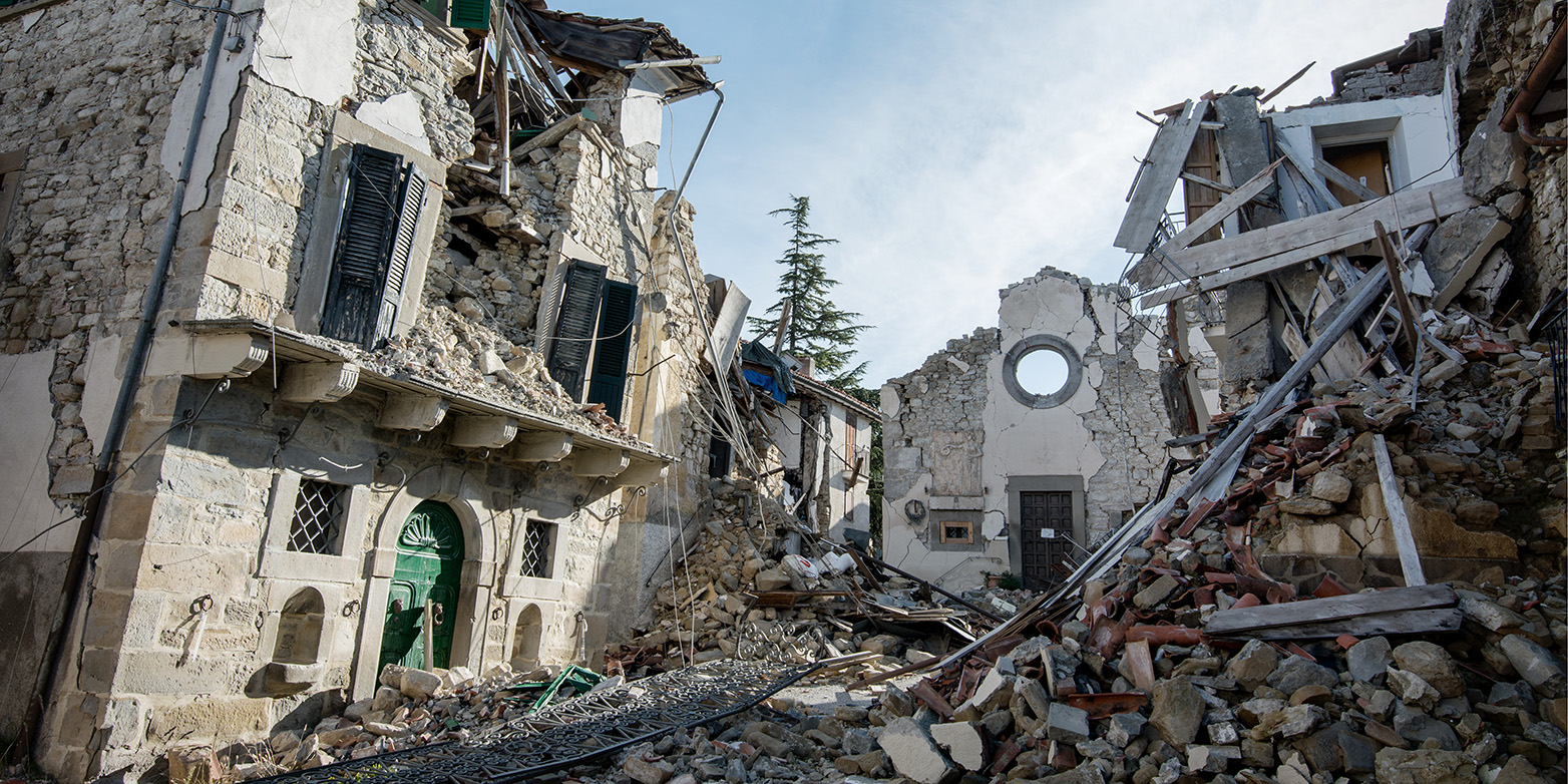
During the 20th century, earthquakes in Europe accounted for more than 200,000 deaths and over 250 billion Euros in losses. Comprehensive earthquake hazard and risk assessments are crucial to reducing the effects of catastrophic earthquakes because earthquakes cannot be prevented nor precisely predicted.
An international team of European seismologists, geologists, and engineers, with leading support of members from the Swiss Seismological Service and the Group of Seismology and Geodynamics at ETH Zurich has; therefore, revised the earthquake hazard model that has existed since 2013 and created a first earthquake risk model for the whole of Europe.
The 2020 European Seismic Hazard and Risk Models offer comparable information on the spatial distribution of expected levels of ground shaking due to earthquakes, their frequency as well as their potential impact on the built environment and on people’s sense of wellbeing.
The newly released update of the earthquake hazard model and the first earthquake risk model for Europe are the basis for establishing mitigation measures and making communities more resilient. They significantly improve the understanding of where strong shaking is most likely to occur and the potential effects of future earthquakes in Europe.
To this aim, all underlying datasets have been updated and harmonised – a complex undertaking given the vast amount of data and highly diverse tectonic settings in Europe. Such an approach is crucial to establish effective transnational disaster mitigation strategies that support the definition of insurance policies or up-to-date building codes at a European level and at national levels.
Open access is provided to both, the European Seismic Hazard and Risk Models, including various initial components such as input datasets.
Improved seismic hazard model

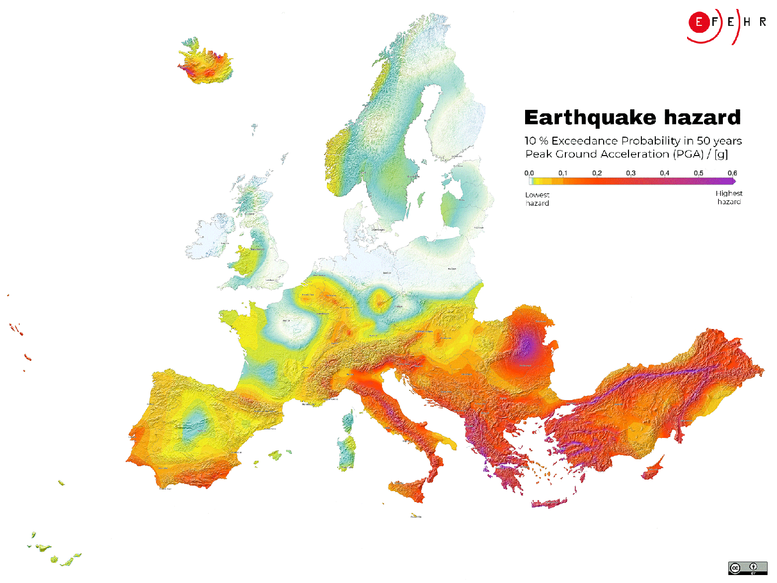
Earthquake hazard describes potential ground shaking due to future earthquakes and is based on knowledge about past earthquakes, geology, tectonics, and local site conditions at any given location across Europe.
The advanced datasets incorporated into the new version of the model have led to a more comprehensive assessment of the earthquake hazard across Europe. In consequence, ground shaking estimates have been adjusted, resulting in lower estimates in most parts of Europe, compared to the 2013 model, and in the case of Switzerland closer to the national model. With the exception of some regions in western Turkey, Greece, Albania, Romania, southern Spain, and southern Portugal where higher ground shaking estimates are observed. The updated model also confirms that Turkey, Greece, Albania, Italy, and Romania are the countries with the highest earthquake hazard in Europe, followed by the other Balkan countries. But even in regions with low or moderate ground shaking estimates, damaging earthquakes can occur at any time.
Furthermore, specific hazard maps from Europe’s updated earthquake hazard model will serve for the first time as an informative annex for the second generation of the Eurocode 8 (European standards related to construction). Eurocode 8 standards are an important reference to which national models may refer. Such models, when available, provide authoritative information to inform national local decisions related to developing seismic design codes and risk mitigation strategies. Integrating earthquake hazard models in specific seismic design codes helps ensure that buildings respond appropriately to earthquakes. These efforts thus contribute to better protect European citizens from earthquakes.
Main drivers of the earthquake risk are older buildings
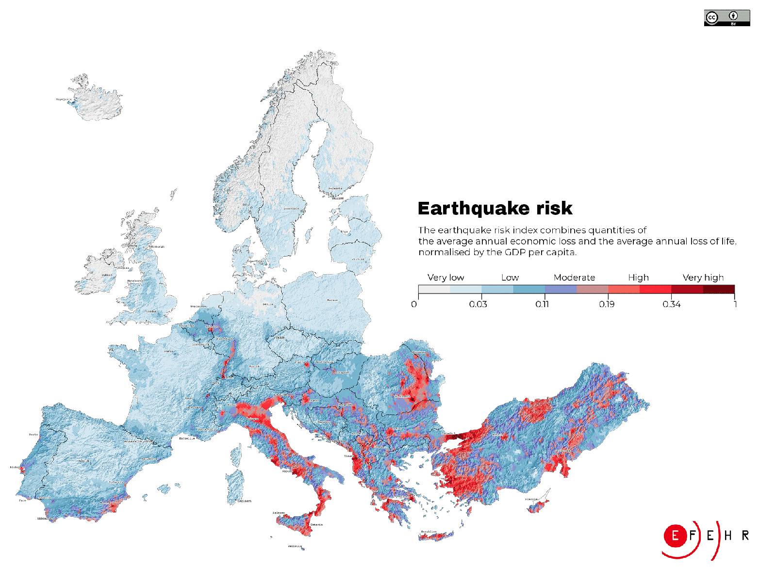
Earthquake risk describes the estimated economic and humanitarian consequences of potential earthquakes. In order to determine the earthquake risk, information on local soil conditions, the density of buildings and people (exposure), the vulnerability of the built environment, and robust earthquake hazard assessments are needed. According to the 2020 European Seismic Risk Model (ESRM20), buildings constructed before the 1980s, urban areas, and high earthquake hazard estimates mainly drive the earthquake risk.
Although most European countries have recent design codes and standards that ensure adequate protection from earthquakes, many older unreinforced or insufficiently reinforced buildings still exist, posing a high risk for their inhabitants.
The highest earthquake risk accumulates in urban areas, such as the cities of Istanbul and Izmir in Turkey, Catania, and Naples in Italy, Bucharest in Romania, and Athens in Greece, many of which have a history of damaging earthquakes. In fact, these four countries alone experience almost 80% of the modelled average annual economic loss of 7 billion Euros due to earthquakes in Europe. However, also cities like Zagreb (Croatia), Tirana (Albania), Sofia (Bulgaria), Lisbon (Portugal), Brussels (Belgium), and Basel (Switzerland) have an above-average level of earthquake risk compared to less exposed cities, such as Berlin (Germany), London (UK), or Paris (France).
Developing the models is a joint effort
A core team of researchers from different institutions across Europe, including the leading support of members from ETH Zurich, worked collaboratively to develop the first openly available Seismic Risk Model for Europe and to update Europe’s Seismic Hazard Model. They have been part of an effort that started more than 30 years ago and involved thousands of people from all over Europe. These efforts have been funded by several European projects and supported by national groups over all these years.
Researchers from the Swiss Seismological Service (SED) and the Group of Seismology and Geodynamics at ETH Zurich led many of these projects. The SED is also home to EFEHR (European Facilities for Earthquake Hazard and Risk). EFEHR is a non-profit network dedicated to the development and updating of earthquake hazard and risk models in the European-Mediterranean region. ETH Zurich thus holds a central hub function for data collection and processing, open access to earthquake hazard and risk models including all basic data sets, and knowledge exchange.
The development of the 2020 European Seismic Hazard and Risk Models has received funding from the European Union’s Horizon 2020 research and innovation programme.
What do the European seismic hazard and risk models mean for Switzerland?
One important aspect of earthquake mitigation that relies on hazard models is the development of construction standards for earthquake-resistant structures. In Switzerland, this task is the responsibility of the Swiss Society of Engineers and Architects (SIA), which takes as its basis the national hazard assessment prepared by the Swiss Seismological Service at ETH Zurich, last updated in 2015. This is standard practice in countries and regions for which comprehensive hazard assessments are available. The reason for this is that national models depict local conditions with greater precision and in a higher resolution than European models. Nevertheless, the relevant SIA committee will study the new European model closely and analyse possible differences vis-à-vis the national model. However, this is not expected to result in any changes to the currently applicable SIA standards for earthquake-resistant construction.
Work under way on national seismic risk model
In contrast to seismic hazard, Switzerland does not yet have a national model for seismic risk. The SED is currently developing such a model in collaboration with the Federal Office for the Environment and the Federal Office for Civil Protection. Due to be published next year, it will show in great detail the damage that can be expected to occur in Switzerland as a result of earthquakes. As with the seismic hazard model, the national seismic risk model will reflect the specific characteristics of Switzerland more accurately than the European model and will therefore serve as the primary reference for Switzerland-wide risk analyses. However, the European model is helpful when it comes to making risk comparisons between countries.
European results provide indications of high-risk regions
Initial analyses by the SED suggest that the European seismic hazard assessment differs only minimally from the national assessment. There is currently no reference for seismic risk, but in the European model Basel and Geneva stand out as places at particularly high risk in Switzerland.
This is hardly surprising in the case of Basel, as all relevant seismic risk factors come together there: a high density of residents and property, a high seismic hazard and many vulnerable buildings.
Compared with Basel, Geneva has a lower seismic hazard. However, a fault zone in the French Alps plays a key role in the European risk model as a possible source of more distant but potentially large earthquakes. As with Basel, there is also a high density of residents and property and a vulnerable building stock, much of which is built on soft subsoil that is not good for earthquakes (sedimentary basin).
Furthermore, on the map in the European model, the core zone in Geneva lies in a single cell, whereas in Zurich, which has similar conditions, it is spread across three cells. From a purely visual point of view, therefore, the risk appears greater for Geneva than for Zurich, for example.
The fact that other urban or particularly vulnerable Swiss areas do not show up more strongly in the European seismic risk model is mainly due to two factors. Firstly, Swiss cities tend to be small by European standards and are therefore at less risk than other large urban areas. Secondly, the results are normalised with gross domestic product (GDP). In other words, the risk assessment takes into account a country's ability to mitigate the effects of an earthquake.

Comments
No comments yet